Director’s Notebook:
I’ve conducted interviews at many government agencies in the past, but my first visit to the National Space Agency (TASA) was also my first going into a “highly restricted area”. Before Dr. Chang Li-Yu brought me inside, I had to type in my personal information such as name, company, position, address, telephone number, and email into their computer system. As I waited to go in, I felt a bit nervous because as I was preparing for my interview, I found it hard to understand topics like satellites, space, and image processing. However, I was happy to find out that Dr. Chang would be such an incredible storyteller whose expertise covered agriculture, marine science, and disaster management and could explain everything in between the heavens using satellite imagery.
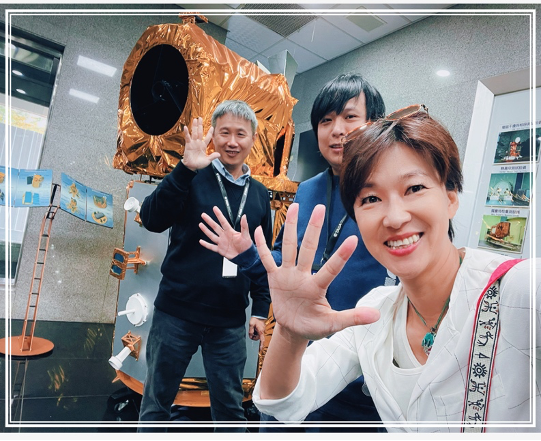
Picture 1: Dr. Chang Li-Yu (Left) and Assistant Researcher Wei Xuan-cheng (Middle) in Front of Formosat-5 (Taken By Pei Lin-lin at TASA)
Processing 60,000 Satellite Images Is No Easy Feat
After interviewing National Space Agency Satellite Data and Equipment/Infrastructure Development Department Director Dr. Chang Li-Yu, I realized that no one can outperform him in terms of being able to tell a story from a picture. There’s a saying that if you want to be an expert in your field you need at least 10,000 hours of practice. So I was very impressed when I heard that Dr. Chang only wrapped up a study after analyzing 60,000 images of Thailand’s rice crops and environmental monitoring from 2021 to 2024 during a cooperation project between the National Academy of Sciences of Thailand and the National Center for High-performance Computing. This project took place in Thailand but used Taiwan’s data ecosystem and multi-dimensional and multi-sequential remote sensing data to jointly develop an agricultural remote sensing image recognition system.
In his patent eloquence, Dr. Chang said that before this, Thailand relied on “manpower” to gather information on the country’s rice crops. Each survey took around two years to conduct. However, rice can be harvested every three to four months. Since Thailand has three harvests in a single year, updates to rice surveys used to take place after the fact. However, Taiwan’s capacity in satellite imagery enhanced the speed of conducting rice surveys. In addition to being able to update food policy promptly, these improvements have improved the country’s food security. As such, the first stage of this project focused on pattern construction, which involved first using a small area to verify the feasibility of conducting remote sensing image analysis. The second stage took the aforementioned data and put it into the Taiwan Data Cube and then conducted a larger-scale analysis in a province of central Thailand. The third stage was conducting image analysis on rice crops across the entire country.
Now the question is, how does someone make use of these 60,000 images? The satellite monitoring images used in this project were paired with high-resolution imagery from Taiwan's Formosat-5, as well as medium-resolution data from the European Space Agency's Sentinel-1 and Sentinel-2. In theory, combining the Formosat-5 satellite’s 2-meter by 24-kilometer pixel high-resolution images, along with 10-to-20-meter by 200-kilometer pixel medium-resolution images from the two Sentinel satellites, allows for comprehensive multi-resolution satellite image analysis. This approach utilized the project’s resources in the most efficient manner possible.
Unlike the way your average person sees satellite images as mere photographs, Dr. Chang looks at satellite imagery much differently. For Dr. Chang, satellite images can utilize information from the near-infrared spectrum to assess whether the structure of rice "cell walls" is damaged. This enables further analysis of rice crops in terms of health and damage. Dr. Chang put on a smile when he said, “Thailand didn’t just want us to monitor rice fields. They also hoped we could help out with remote sensing on sugar cane as well.”
In terms of analysis, Dr. Chang went on to point out, “In addition to the differences in the growth cycles of rice and sugarcane, satellite imagery utilizes the near-infrared spectrum, which is the least utilized wavelength for energy absorption in plants. As a result, plants reflect half and transmit half of near-infrared light through their cell walls. If the cell wall structure has been externally affected and damaged, the aforementioned effect in the near-infrared spectrum ceases to exist. This allows for a preliminary assessment of the plant's health. To further validate the accuracy of remote sensing image interpretation, a cross-reference is made with “boots-on-the-ground data" that Thailand collected by hand in 2019.” Dr. Chang’s colleague Assistant Researcher Wei Xuan-cheng pointed out that at this stage, the analysis can further incorporate the "shortwave infrared bands" of the Sentinel-2 satellite to examine water content, which is a crucial health indicator in crops. In essence, these 60,000 satellite images are useless to the untrained eye, but thanks to Dr. Chang, these images transform into a captivating narrative of rice cultivation in Thailand.
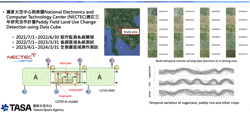
Picture 2: Taiwan-Thailand Cooperation in Remote Sensing Imagery Application (Courtesy of TASA)
Putting Taiwan’s “Eye in the Sky” To the Test
In addition to Thailand, TASA has also partnered with the International Cooperation and Development Fund (ICDF) for many years. Farmers of Taiwan’s partner countries have welcomed the collaboration with this non-profit. For example, in 2021, a banana plantation in Colombia was suddenly hit by yellow leaf disease. This unfamiliar disease caused farmers to hastily cut down a large portion of their banana plantations. Furthermore, the farmers prohibited the cultivation of bananas after burning their soil and isolating their crops. Their harsh response was due to the fact that such a disease had never appeared in Central and South America before. Columbian farmers were aware that Taiwan had successfully defeated this formidable opponent in the past. As such, they urgently sought assistance from ICDF.
Dr. Chang went on to explain that, "Yellow leaf disease causes leaves to wither and turn yellow. However, the disease’s pathogenic mechanism involves bacteria living in the soil that disrupt the banana's water transport system. Once the water transport system is damaged, banana trees quickly wither and die. Because bacteria also spread rapidly, Taiwan experienced a major outbreak several decades ago, which significantly impacted our banana production. After conducting further R&D, the bananas in Taiwan are now varieties that are resistant to yellow leaf disease."
Bananas in Central and South America serve as a staple food while in Taiwan people only eat bananas as fruit. Therefore, an outbreak of disease would impact the economy as well as food security in that part of the world. Thus, the Organization for Agricultural Health in Central America (OIRSA) has collaborated with ICDF to strengthen agricultural pest control and research on crop improvement. Subsequently, monitoring efforts have been expanded thanks to ICDF's recommendations. TASA aims to achieve early warning capabilities by utilizing satellite imagery to conduct large-scale monitoring on plant diseases.
OIRSA came up with an idea to test just how powerful Taiwan's “eye in the sky” really is. During the test, they secretly used herbicides to kill several trees in order to see if the system could accurately “catch” the affected location. With a shy smile, Dr. Chang mentioned that this was the first time encountering such a challenge. He was a bit nervous, fearing what would happen if the answer was not "correct." However, the system spoke for itself. Records show that herbicides were sprayed at the end of February, and within about a week, the trees died. Colleagues from the TASA's Satellite Data and Equipment/Infrastructure Development Department promptly identified the correct location in early March, proving that satellite imagery for crop monitoring is not only very timely but also highly accurate. From November 2022 to July 2023 alone, TASA released 123 regular reports and 38 abnormal reports. This series of large-scale plant disease control exercises in Central America has validated the feasibility of using satellite monitoring for early warning and disease prevention.
Taiwan’s Capabilities in Space Turning Heads- Helping the International Community with Satellites
Taiwan’s satellite monitoring goes beyond just farmland. Moreover, it takes more than just agricultural knowledge to understand these images. In today's international space endeavors, collaboration is more powerful than individual efforts. Held in Indonesia in 2023, the 29th Session of the Asia-Pacific Regional Space Agency Forum (APRSAF-29) reflected these truths. Dr. Chang pointed out that during that conference, Taiwan's capabilities in space observation were acknowledged and praised by multiple nations because experts and scholars from various countries participated in the important event.
The maritime pollution crisis that occurred at the end of February 2023 in the Philippines exemplified Taiwan’s capacities in remote sensing. At the time, a cruise ship carrying 800,000 liters of oil sank near Mindoro Island. The subsequent spill significantly impacted the area’s marine ecology. The situation was dire and compounded by the Philippines’ lack of domestic satellite capabilities. Therefore, Sentinel-Asia, an international rescue organization, issued an urgent request to its members for emergency observation assistance.
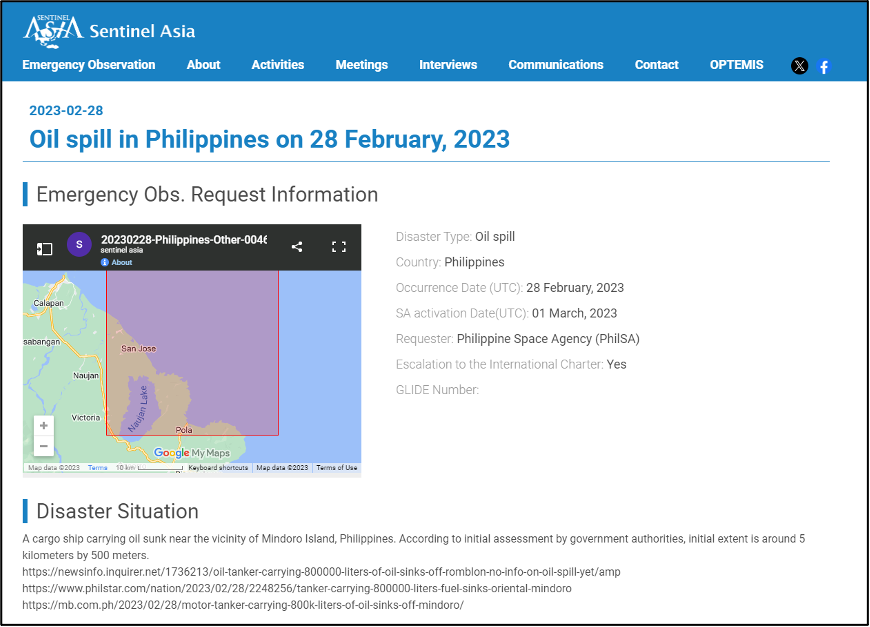
Picture 3: Sentinel-Asia Issuing a Request for Emergency Observation Assistance on its Website
Due to the different repeat cycles of individual satellites, a Thai satellite captured the first image of the oil spill. However, only Taiwan's Formosat-5 had a two-day repeat cycle. Therefore, during the first eight days, TASA provided three out of the four key satellite images. At this point, Dr. Chang pointed out, "Due to viscosity, when oil initially leaks onto the sea surface, it is very sticky and remains as a thin line without spreading. However, after interacting with seawater, emulsification reduces viscosity. Therefore, the area impacted by pollution gradually expanded on the second, fourth, and sixth days. From 2.9 km² to 3.5 km² and finally 4.4 km² respectively. However, by the eighth day, the oil spill rapidly expanded, resembling an explosion on the sea surface, reaching 11.39 square kilometers." Cross-border cooperation in emergency observation helped the international community recognize Taiwan's capabilities in satellite imagery.
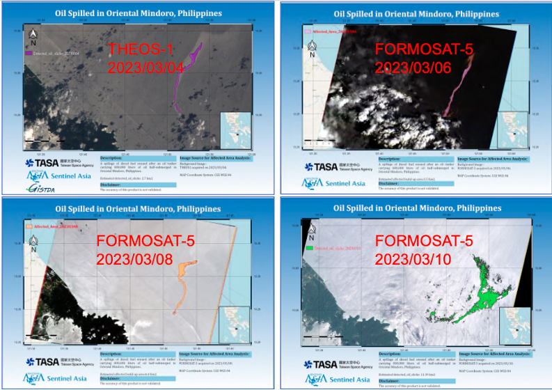
Picture 4: Identification and Detection of Coastal Oil Slicks during an Oil Spill near the Philippines
My interview with Dr. Chang covered a wide range of topics spanning from monitoring in agriculture, marine environments, wildfires, and landslides. To interpret satellite images, it’s not enough to just be an expert in astronomy and geography. So, I couldn't help but ask Dr. Chang if he feels a lot of pressure at work. He squinted and smiled, saying, “The Satellite Data and Equipment/Infrastructure Development Department is just one of the teams at TASA. There are many, many other people responsible for building rockets, manufacturing satellites, and integrating testing. Everyone has specialized skills, and each role is indispensable. That's the interesting part of working at TASA. It's incredibly interdisciplinary, and it feels like crossing mountains when moving between fields."
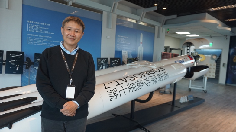
Picture 5: Dr. Chang with a Model of the Formosat-7 Falcon Heavy Rocket (Taken By Pei Lin-lin)
As I thought back on my interview, the saying "Every grain of rice takes countless hours under the sun" came to mind. Now this saying means being grateful for farmers under the sun but also the experts who interpret the data from satellite images taken far above the earth. Through international cooperation and mutual assistance, these experts silently protect our rice fields, orchards, and oceans while ensuring food security and preventing disasters.
.png)
Picture 6: Dr. Chang Introducing the Satellite Data and Equipment/Infrastructure Development Department (Taken By Pei Lin-lin)
Columnist
.png) Pei-lin Lin
Pei-lin Lin
Pei-lin Lin obtained her B.A. in Philosophy from Fu Jen University and her M.A in Political Science from National Taiwan University. Lin embodies a humanistic literacy and political sensibility. In recent years, Lin has collaborated with the Taiwanese government to shoot videos promoting various policies. Currently, Lin splits her time between running a Chan Lands Ltd., Zongdipan, making documentary films and hosting the podcast “Human Translation Machine.” In the past, Lin has been a reporter for several media outlets and the anchor of shows on TVBS, CBC and Da Ai Television. While at Da Ai Television, Lin’s piece “Muhammad Yunus- Savior of the Poor,” was nominated at the First Taiwan Golden Wheel Awards for Outstanding Television News Feature.